ESA satellite imagery shows wildfire smoke and active fire fronts over Spain and France
ESA published Copernicus imagery showing aerosol pollution over Spain and France after days of wildfire spread through dry countryside [2]. A second ESA image zooms in on the Cebreros ground station near Madrid and notes that more than 90,000 people were evacuated from the Ávila region, while Coper…
ESA published Copernicus imagery showing aerosol pollution over Spain and France after days of wildfire spread through dry countryside [2]. A second ESA image zooms in on the Cebreros ground station near Madrid and notes that more than 90,000 people were evacuated from the Ávila region, while Copernicus emergency mapping was activated to monitor the fires [8].
Why it matters: These images turn wildfire impacts into measurable atmospheric and infrastructure events, showing how space-based observation supports public health, emergency response, and mission operations on the ground [2][8]. The Cebreros update also shows that deep-space infrastructure can sit inside an active disaster zone yet still be assessed for safe operation [8].
Key insights: Sentinel-5P data on July 26 showed aerosol index over Spain and France after wildfire spread [2]. | ESA says the aerosols came from three fire areas: Gironde near Bordeaux, the Ávila region, and north of Valencia [2]. | ESA’s Cebreros station, 77 km west of Madrid, remained safe for nominal operations as of the morning of July 27 [8]. | The Cebreros imagery highlights that Copernicus Emergency Mapping was activated on July 23 to support wildfire monitoring in central Spain [8].
Cheatsheet facts: What changed: ESA released satellite views of wildfire smoke and a separate image of the Cebreros station area under fire conditions [2][8]. | Why now: Wildfires in Spain and France have produced widespread smoke and evacuations, prompting emergency mapping and atmospheric monitoring [2][8]. | Watch next: Look for additional Copernicus wildfire products or ESA updates on the operational status of affected ground assets [8].
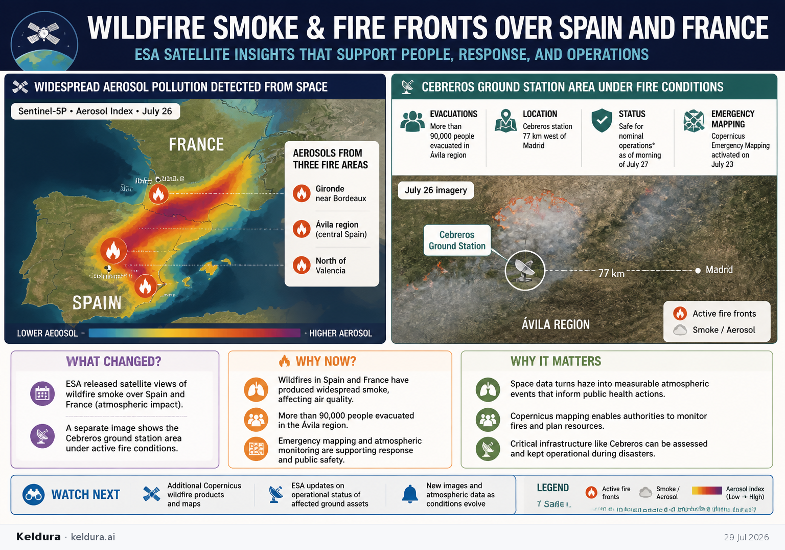
ESA published Copernicus imagery showing aerosol pollution over Spain and France after days of wildfire spread through dry countryside [2]. A second ESA image zooms in on the Cebreros ground station near Madrid and notes that more than 90,000 people were evacuated from the Ávila region, while Copernicus emergency mapping was activated to monitor the fires [8].
Why it matters: These images turn wildfire impacts into measurable atmospheric and infrastructure events, showing how space-based observation supports public health, emergency response, and mission operations on the ground [2][8]. The Cebreros update also shows that deep-space infrastructure can sit inside an active disaster zone yet still be assessed for safe operation [8].
Key insights: Sentinel-5P data on July 26 showed aerosol index over Spain and France after wildfire spread [2]. | ESA says the aerosols came from three fire areas: Gironde near Bordeaux, the Ávila region, and north of Valencia [2]. | ESA’s Cebreros station, 77 km west of Madrid, remained safe for nominal operations as of the morning of July 27 [8]. | The Cebreros imagery highlights that Copernicus Emergency Mapping was activated on July 23 to support wildfire monitoring in central Spain [8].
Cheatsheet facts: What changed: ESA released satellite views of wildfire smoke and a separate image of the Cebreros station area under fire conditions [2][8]. | Why now: Wildfires in Spain and France have produced widespread smoke and evacuations, prompting emergency mapping and atmospheric monitoring [2][8]. | Watch next: Look for additional Copernicus wildfire products or ESA updates on the operational status of affected ground assets [8].
X copy pack
Edition complete
You've reached the end of this edition.